The City of Burnaby says it will soon begin phase two of public consultation for one of the two proposed village community plans that could dramatically alter the face of some local neighbourhoods.
In the summer of 2020, city council gave staff the go-ahead to begin public consultations on developing urban village plans for the Bainbridge and Lochdale areas – the former located around the Sperling SkyTrain station and the latter at the east end of Hastings Street.
Assistant director of current planning Jesse Dill said in August 2020 that the intention was to increase the city’s housing stock beyond the four town centres, where plans call for high-density developments – namely high- and mid-rise apartment buildings.
In the urban villages, developments would lean more on gentle density, a term for row housing, low-rise apartment buildings and duplexes.
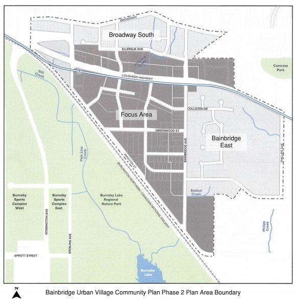
Bainbridge is loosely defined – Dill said the boundaries for the area are “quite fluid” – by Sperling Avenue to the west, Winston Street to the south, Bainbridge Avenue to the east and Ellerslie Avenue to the north.
The area has mostly single-family housing in the southeast half, while the northwest is taken up by warehouses, including Saputo Dairy (which sold its Burnaby property to a developer), and some commercial properties.
But with all the transportation corridors nearby, Dill said it’s a prime location for more development. He noted the area is currently much less densely populated than is typical for a SkyTrain station.
“It’s an opportunity for a mixed-use, thriving, complete community with varied housing options, employment, park space and open space,” Dill said. “It’s really, for Bainbridge, a transformation of, historically, an industrial area.”
He noted the neighbourhood is home to a number of larger properties and “underutilized” sites, which he said could be put to use to achieve some of the city’s goals, particularly around housing affordability.
According to a proposed land-use map, the village centre would be directly around the SkyTrain station, on the south side of Lougheed. There, Dill said, the area would see the “gateway to the community” and the cultural hub, with the most diversity of uses and the most dense developments.
At a May 31 city council meeting, staff presented the findings of the first phase of public consultation for the Bainbridge Urban Village Community Plan.
The city says the plan aligns with the following city policies:
- Corporate Strategic Plan (2017)
- Regional Context Statement (2013)
- Official Community Plan (1998)
- Economic Development Strategy (2016)
- Social Sustainability Strategy (2011)
- Environmental Sustainability Strategy (2016)
- Mayor's Task Force on Community Housing (2019)
- Housing Needs Report (2021)
- Climate Action Framework (2019)
- Transportation Plan Update (ongoing)
According to a report, the online survey saw a total of 506 responses, with 63% saying they would support some expansion of the focus area to one of either Bainbridge East, Broadway South or both areas.
From the public input, the following key themes were identified:
- Parks, open space and the natural environment
- Local economy and employment
- Development and community design
- Housing
- Community amenities
- Transportation and mobility
- Plan area boundary
City council gave the go-ahead on May 31 for phase two of public consultations to begin.
A full report including phase one results can be found online by the City of Burnaby.
- With files from Dustin Godfrey, Burnaby NOW


