Tanager George is mapping the future.
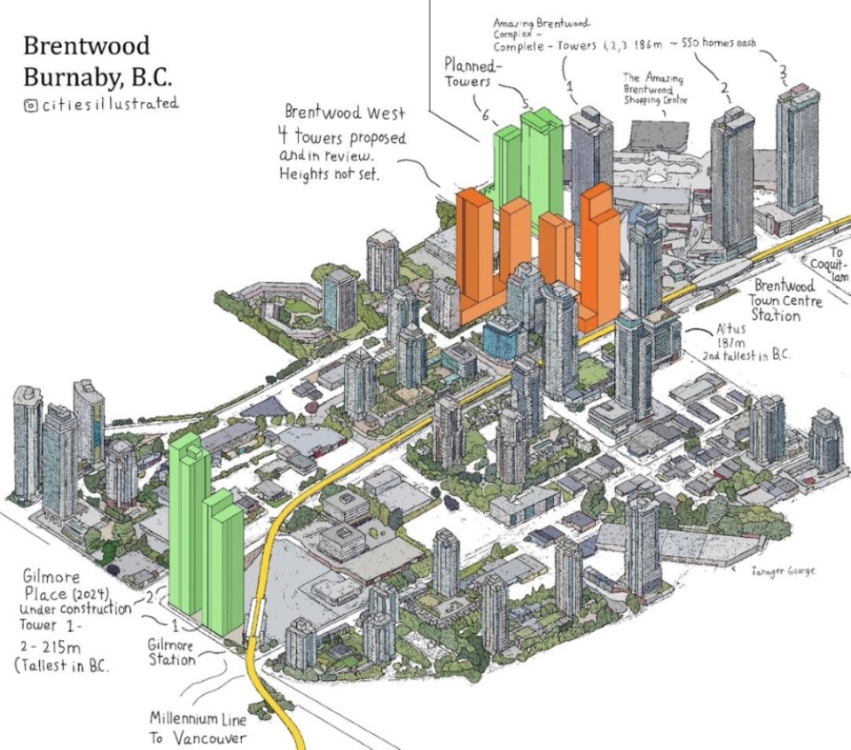
The artist from California has designed a library of maps from all over the world, and his latest creation featured Burnaby’s own Brentwood town centre.
Many of George’s illustrations show cities as they stand in the present day.
But his map of Brentwood also features pencilled-in renderings of future highrise towers planned in the neighbourhood.
So why would an artist, who’s created maps of major cities like Tokyo, San Francisco and New York, zero in on what could be seen as peripheral, suburban Brentwood?
George, who spoke to the NOW from Thailand, said he keeps up to date on architecture and development trends around the world.
His interest in transit-oriented development drew him to SkyTrain-centred Brentwood.
“I just remember learning about how much development is going on in Brentwood, Burnaby, and I was really interested in that,” George said.
“(Burnaby’s) going to have a taller building than any in Vancouver. I thought that was very interesting that a suburb would take that title away from its main city.”
Sure enough, his Brentwood map includes Gilmore Place, an under-construction 64-storey tower project that will be about 214 metres/702 feet high and will knock off Vancouver’s Living Shangri-La tower (196.9 m/646 ft) from its pedestal as the tallest in the province. (And an almost-approved project at Lougheed could soon blast Gilmore’s height out of the water at 259 m/850 ft.)
George shared his architectural renderings on the Vancouver subreddit page, to Redditor acclaim.
“This is extremely impressive. Do you do this professionally?” asked one user.
“I really like your style. I hope cities, BIAs, building owners, etc hire you. Illustrations like this are so much more meaningful than maps or 3D renderings,” wrote another.
George explained developers’ promotional renderings are usually from a human or aerial point-of-view, but it’s almost always just focused on their building.
“They won’t usually include surrounding developments or other things, maybe because it would take more time do so, or maybe they only want to promote their own product,” he said.
“What I’m doing is just combining all of their promotional material, basically, into one single map.”
He said it could be useful for potential homebuyers to visualize distances of where major attractions are relative to other locations.
Brentwood’s development
George noted several Reddit commenters on his map post criticized the Brentwood area.
One commenter wrote Brentwood has the vibe of a “concrete hellscape”; another said, “They are promoting all this housing at transit, which is awesome, but then they say, ‘thanks for taking transit, here are two 8-lane roads that you have to cross to get to your grocery store.’”
George agreed.
“It doesn’t seem like there’s a lot of thought or incentive being given to the developers to make (the area) really walkable and pleasant to be around these buildings, like when you’re commuting, when you’re walking,” adding, “The pedestrian experience (in Brentwood) seems pretty poor.”
His suggestion for Brentwood? A “park cap,” like in Philadelphia, Pa. or Houston, Texas.
“That’s a popular trend in the United States right now … where they have these huge highways bisecting the city, and now they’re putting parks on top of it. So, like, a park right over Lougheed at Brentwood Town Centre station would really just be perfect. … It would allow people to walk to the station without having to cross that street.”
George noted his rendering doesn’t include all the approved Brentwood master plans, adding he’d like to update the map at some point.
“That whole area is going to be turned into a mini-skyline of its own – not that it already isn’t, but it’s just going to be covered with buildings.”
Mapmaking
The first map George did, which “blew up” online, was a map of Tokyo with the rail network.
His detailed map of Vancouver generated a host of British Columbian followers.
The Brentwood map took him about a day and a half to create, where the Vancouver one (described as “2D faux-3D style”) took around two weeks.
After attending architecture school, but leaving without a degree, George said he’s been working on his cartographic style for about a year.
He keeps a lock on the system he uses to develop the maps (which includes analyzing Google Maps and Google Earth) – for now.
He might create a course on the style, he said.
One day, George says he’d like to get a degree and join the industry.
You can purchase high-quality prints of George’s maps, including one of downtown Vancouver, on George’s Etsy shop or visit his Instagram @citiesillustrated.


