The City of Burnaby is seeking to increase “gentle density” in a couple of neighbourhoods by developing the areas as “urban villages.”
City council gave staff the go-ahead to begin public consultations on developing urban village plans for the Bainbridge and Lochdale areas – the former located around the Sperling SkyTrain station and the latter at the east end of Hastings Street.
Jesse Dill, assistant director of current planning, said the intention was to increase the city’s housing stock beyond the four town centres, where plans call for high-density developments – namely high- and mid-rise apartment buildings.
In the urban villages, on the other hand, developments would lean more on gentle density, a term for row housing, low-rise apartment buildings and duplexes.
Both areas, Dill noted, are high-traffic areas, seen as key for housing density. Lochdale sees plenty of traffic to and from SFU, as well as Hastings’ commercial areas, while Bainsbridge is at the confluence of Sperling Avenue, Lougheed Highway, the Millennium SkyTrain line and the Central Valley Greenway.
Both areas are also largely made up of older buildings, most of which are 50 years or older and nearing the end of their lifespans.
Dill noted the city can use the opportunity to implement the newly developed city policies around climate action, which seek to achieve community-level carbon neutrality by 2050.
Public consultations for both areas should run along the same timelines, Dill said, particularly as some people will want to weigh in on both urban village plans, given their proximity to one another.
In general, the city expects to begin seeking public input in September, with reports on policy directions expected by early 2021. More public input would be required after that, before staff prepare a draft plan by late spring next year. Still more public input would then be sought before staff bring a final plan to council in September next year.
Bainbridge
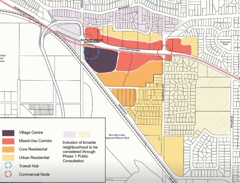
Bainbridge is loosely defined – Dill said the boundaries for the area are “quite fluid” – by Sperling Avenue to the west, Winston Street to the south, Bainbridge Avenue to the east and Ellerslie Avenue to the north.
The area has mostly single-family housing in the southeast half, while the northwest is taken up by warehouses, including Saputo Dairy, and some commercial properties.
But with all the transportation corridors nearby, Dill said it’s a prime location for more development. He noted the area is currently much less densely populated than is typical for a SkyTrain station.
“It’s an opportunity for a mixed-use, thriving, complete community with varied housing options, employment, park space and open space,” Dill said. “It’s really, for Bainbridge, a transformation of, historically, an industrial area.”
He noted the neighbourhood is home to a number of larger properties and “underutilized” sites, which he said could be put to use to achieve some of the city’s goals, particularly around housing affordability.
According to a proposed land-use map, the village centre would be directly around the SkyTrain station, on the south side of Lougheed. There, Dill said, the area would see the “gateway to the community” and the cultural hub, with the most diversity of uses and the most dense developments.
On either side of Lougheed, the city foresees a mixed-use corridor, with commercial uses emphasized at the highway’s intersections with Bainbridge and Sperling avenues.
Directly to the south of that, the city expects to see the “heart of the residential community,” offering a range of housing, starting with higher density and easing into lower density to the south.
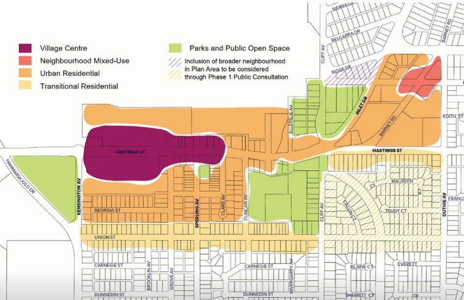
Lochdale

This urban village is currently defined by Hammerskjold Drive to the west, Ridge Drive to the north, Duthie Avenue to the east and Union Street to the south, though that, too, could be amended.
It’s somewhat different from Bainbridge in that it’s already got a commercial centre, along Hastings Street. With that in mind, Dill said the plan is more intended to expand on what’s already in the area, including housing, employment and culture.
Dill defined the area as more of a suburban setting, with much of the commercial areas set back from the roadway, offering larger parking lots, compared to, for instance, the Heights area. This encourages more vehicle traffic, while the goal of the new plan is to encourage all modes of travel, including transit, cycling and walking.
According to the proposed land-use map, the village centre would be focused around the existing commercial properties along Hastings, mostly between Sperling and Kensington avenues, such as the Kensington Square mall. There, Dill said, the city envisions commercial uses at street level, with potential housing or office space above.
Directly surrounding that and reaching into the Barnet Road area, the city suggests an urban residential area, with some more minor density, while areas to the south would ease back into the low-density residential area that surrounds it.
The plan also includes two potential new parks on either side of Hastings and a small neighbourhood mixed-use section at the northeast end.
Dill noted the intention in community consultations in both areas is to maintain a community identity and particularly stressed that point regarding the Lochdale area.


