Big changes are coming to three Burnaby neighbourhoods as new community plans are in the works.
The city is about to launch a public consultation phase to get feedback on how residents think the Edmonds, Royal Oak and Cascade Heights (which is beside Burnaby Hospital) neighbourhoods should develop.
The master plans will act as a policy guide for the future of the neighbourhoods’ goals in housing, transportation (like roads, bus routes and public spaces), park space, employment and business, and climate action.
The plans offer suggested boundaries for each of the neighbourhoods, but they’re not set in stone at this point – the borders for each neighbourhood will be further shaped during the consultations.
The city estimates the timeline for the community plans to run as follows:
- Phase 1 (spring-summer 2023): Preliminary engagement
- Phase 2 (fall 2023-winter 2024): Draft plan, seeking input on a draft with a general structure
- Phase 3 (summer 2024): Detailed draft plan, final consultation phase
- Plan adoption (fall 2024)
The Cascade Heights plan could be completed earlier (around summer 2024) due to its smaller size, depending on public engagement in Phase 1.
While Edmonds is a town centre, Royal Oak and Cascade Heights are designated as “urban villages” which are communities that act as a bridge between high-density town centres and single-family neighbourhoods.
The city has plans for Edmonds and Royal Oak to incorporate “creative employment use” areas intended to foster “a range of creative economy or creative employment uses,” for places like arts and craft studios, workshops, galleries, small-batch manufacturers and flex-industrial spaces.
The report says creative employment uses are “expected to be environmentally friendly and non-disruptive.”
Cascade Heights could see specialized housing for hospital staff and daycare spaces prioritized near the hospital.
Council will review the plans at its next meeting in June before officially heading to public consultation.
Edmonds Town Centre community plan
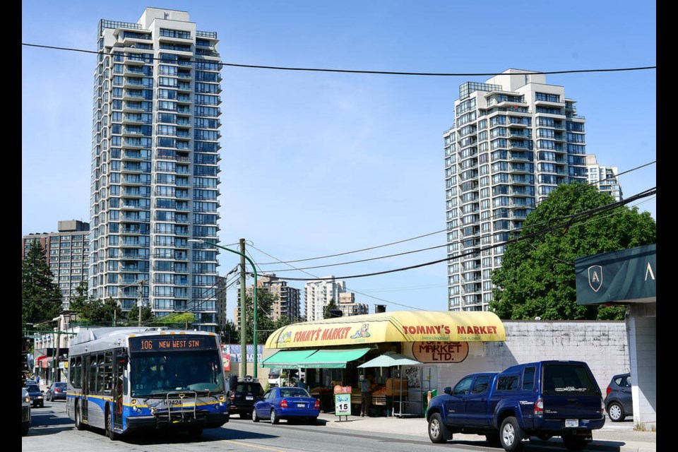
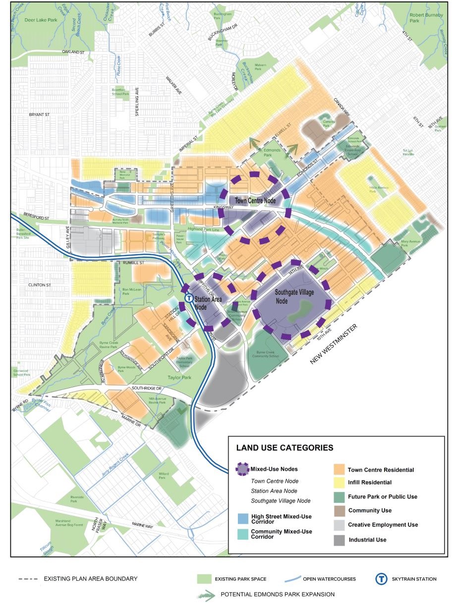
The Edmonds neighbourhood, one of Burnaby’s four major town centres, is at 908 acres the largest geographical town centre in the city.
In a report, staff noted it’s one of the most diverse neighbourhoods in the city.
Edmonds, Burnaby’s first downtown and home to the first municipal hall at Kingsway and Edmonds Street, “was and is a major hub of activity in the city,” according to the report.
The city says a “more contemporary urban fabric for Edmonds was identified,” with three defined areas, or “nodes”:
- The Town Centre Node: Kingsway and Edmonds Street – potential building heights from 35 to 50+ storeys
- The Station Area Node: around the Edmonds SkyTrain station – potential building heights from 20-40 storeys
- The Southgate Village Node: at the Southgate development in the southeast of Edmonds – potential building heights in the mid 40-storeys range
At this stage, all nodes would likely see high-density residential and mixed-use buildings, while the Kingsway corridor would see medium-density, midrise buildings.
Other residential areas in Edmonds would include low to midrise apartments, as well as “missing middle” housing like townhomes and rowhomes.
A southwest section of the neighbourhood is currently designated as industrial use (including B.C. Rapid Transit’s headquarters) and public consultation will ask whether it should remain that way or if “alternative uses may be considered.”
The report says the new plan should “better integrate new development with existing and future urban surroundings, as well as measures to maintain and enhance the community’s unique makeup and culture.”
Royal Oak urban village community plan
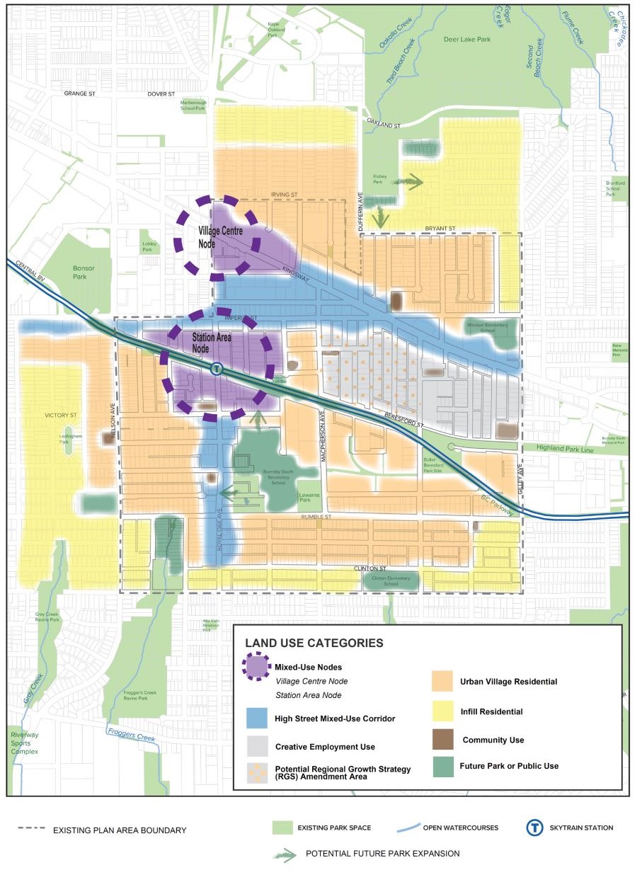
Between the Metrotown and Edmonds town centres, Royal Oak is made up of 554 acres which staff described as “an area of transition with traditionally industrial and commercial uses north of the SkyTrain … and residential uses to the south.”
The starting framework for land use features two “nodes”:
- Station Area Node: Around Royal Oak SkyTrain station – transit-oriented development as the “main public transit gateway” with higher residential and mixed-use buildings; buildings heights up to 20 storeys adjacent to SkyTrain
- Village Centre Node: Kingsway and Royal Oak Avenue – medium to high-density buildings, with taller buildings along Kingsway; building heights up to 25 storeys, with a “signature building” up to 30 storeys at Royal Oak and Kingsway
Outside of the nodes, the preliminary framework includes a creative employment use area east of the Village Centre and north of Beresford Street.
Local, small-scale services and businesses would be concentrated along Kingsway, Royal Oak Avenue and Imperial Street, “serving the 15-minute city model throughout the urban village.”
Staff want Phase 1 to consider how to maximize Royal Oak’s “strategic location as a transit-oriented urban village” and enhance Kingsway, Royal Oak and Imperial Street as “vibrant commercial corridors.”
The report also notes the city wants to use city-owned sites in the area for non-profit and supportive housing.
Staff also want to “support a network of integrated ‘third places’ (parks, places of worship, cafes, bookstores) outside of homes and workplaces that intrigue people of diverse cultural backgrounds, income levels and demographics to explore the urban and natural environment, while developing a distinct identity for Royal Oak.”
The city will also seek ways to preserve heritage resources, especially west of Nelson Avenue.
Cascade Heights urban village community plan
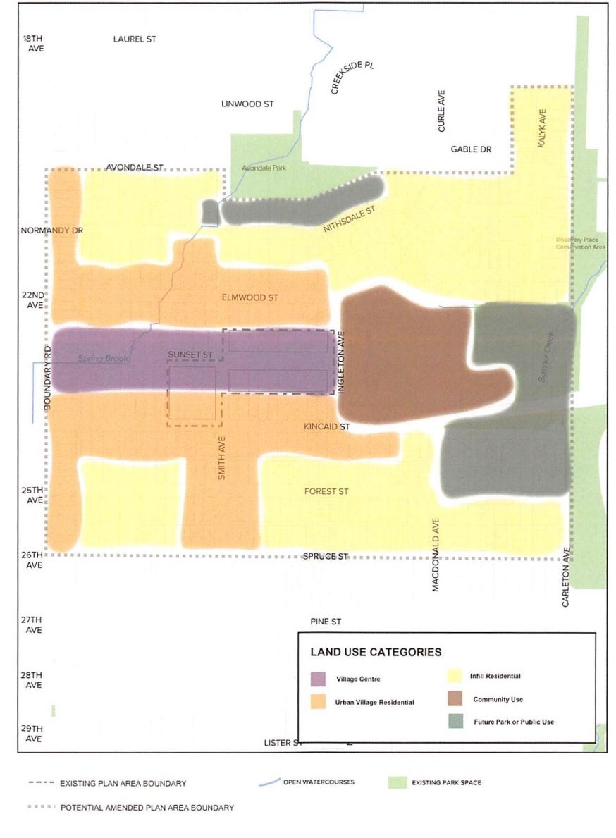
Directly to the west of Burnaby Hospital, Cascade Heights is currently mostly made up of single-family and two-family homes, along with several lowrise multifamily apartments and businesses along Sunset Street.
The area has never had a comprehensive community plan.
The plan considers adding higher density midrise buildings along Sunset Street and redeveloping aging buildings in the Village Centre.
The Village Centre would be one of two areas:
- The Village Centre: along Sunset Street between Ingleton Avenue and Boundary Road – would include locally serving businesses like cafes, restaurants, convenience stores and small grocers with wide sidewalks; medical and health-related offices and services would also be encouraged – potential building heights up to six storeys
- Urban Village residential: low to midrise apartments between four and six storeys
Other goals of the plan include prioritizing daycare spaces and community facilities close to the hospital and looking for opportunities to provide specialized housing for hospital staff and daylighting Spring Brook (a tributary of Still Creek).
The current plan only includes a two-block area along Sunset Street between Smith Street and Ingleton Avenue. Consultation will consider expanding the plan boundaries.
Open houses for Phase 1 public consultation are currently scheduled for:
- Cascade Heights – Thursday, June 29 from 5:30 to 8 p.m. at Wesburne Community Centre (4781 Parkwood Ave.)
- Edmonds – Tuesday, July 4 from 5:30 to 8 p.m. at Edmonds Community Centre (7433 Edmonds St.)
- Royal Oak – Wednesday, July 19 from 5:30 to 8 p.m. at Bonsor Recreation Complex (6550 Bonsor Ave.)
[email protected]
twitter.com/lauvande
📢 SOUND OFF: What do you think of the proposed changes to the Edmonds, Royal Oak and Cascade Heights community plans? How do you envision the future of those neighbourhoods? Share your thoughts — send us a letter.


